| Tweet |

Custom Search
|
|
 
|
||
|
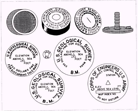
The vertical distance, measured during leveling, is the difference of elevation between two points. The term elevation refers to the height of a point or a particular spot above or below a reference line, called a datum or datum plane. Datum are of two general types: actual and assumed. An actual datum is mean sea level (fig. 15-46). An assumed datum plane is an imaginary level surface assumed to have an elevation of zero. It is used as a convenience in leveling procedures. A reference point whose elevation is known and marked is called a bench mark (B.M.). It is used either as the starting point in leveling or as a point of closure in checking the accuracy of your work. Bench Marks Bench marks are classified as temporary or permanent. Temporaary bench marks (T. B. M.) are established for the use of a particular job and are retained for the duration of that job. Throughout the United States, a series of permanent bench marks has been established by various governmental agencies. These identification markers are set in stone, iron pipe, or concrete and are sometimes marked with the elevation above sea level. Typical markers are shown in figure 15-47.
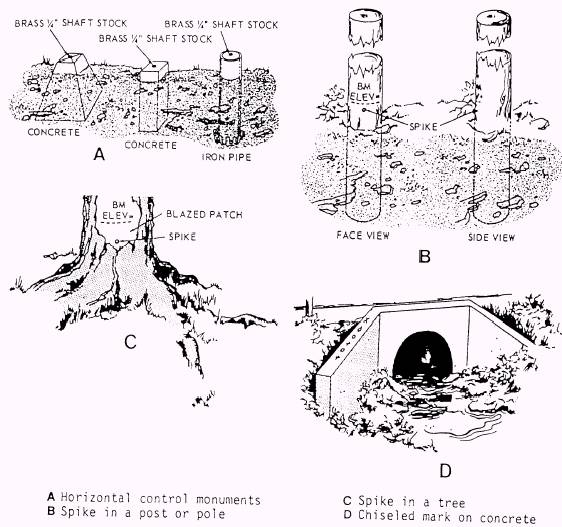
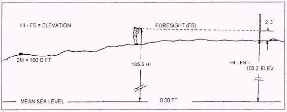
Figure 15-47.-Federal bench marks. 15-27 Any substantial object may be used as a bench mark. Figure 15-48, view A, shows typical monuments set to mark important alignment points, but which may also be used as bench marks. Spikes may be driven into posts or power poles, as shown in figure 15-48, view B, or chiseled into stone or concrete structures, as shown in figure 15-48, view C. For clarity, the marks are shown on the wing wall; but in practice, one mark only is usually chiseled or spray-painted on a flat surface. The location, elevation, and description of bench marks are usually shown on the project drawings or in the surveyor's field notes. Determining Elevations Once a bench mark is established, certain formulas are used for determining elevations. You first must figure the height of the instrument. This is done by taking a reading on a level rod that is placed on a known elevation, such as a bench mark. This is known as a backsight (BS). To determine the height (HI) of the instrument, add the bench mark (BM) elevation to the backsight (BS) reading from the level rod. This formula is written as HI = BM + BS. For example, as shown in figure 15-49, the bench mark elevation is 100.00 feet. The backsight reading
Figure 15-48.-Temporary bench marks. is 5.5 feet. The bench mark elevation, added to the backsight reading, gives a instrument height of 105.5 feet. NOTE: Since the backsight (BS) reading is added to the elevation of the bench mark (BM) to obtain the instrument height, it is usually called a plus (+) sight. Once the height (HI) of the instrument is established, you can determine the elevation of any point within the instrument range. To determine the elevation of a point after the height (HI) has been established, place the level rod on the point in question and take a reading through the level. This sighting is called the foresight (FS) reading and is subtracted from the height to obtain the elevation of the point. The formula for determining elevation is as follows: HI -FS = EL For example, as shown in figure 15-50, the height (HI) of the instrument is 105.5 feet. The foresight (FS) reading is 2.3 feet. The instrument height minus the foresight reading gives that point an elevation of 103.2 feet.
Figure 15-49.-Backsight reading to determine instrument height.
Figure 15-50.-Foresight reading to determine elevation. 15-29 |
 
|
|
|
||