Custom Search
|
|
 
|
||
|
FIELD ENGINEERING SECTION The field engineering section performs such field engineering work as the following: 1. Reconnaissance, preliminary, topographic, and location surveys 2. Construction stakeout; line and grade 3. Regular measurement of quantities of work in place 4. As-built location of structures for preparation of as-built record drawings 5. Measurement and computation of earthwork quantities 6. Calculations for establishing line and grade 7. Plotting survey data 8. Special surveys, such as property, triangulation, hydrographic, and the determination of true azimuth In combat, the field crews gather needed intelligence by scouting, patrolling, and manning observation posts. They are also trained as damage survey teams for emergency recovery operations. Survey Parties As you learned in your previous studies, a survey party is organized and designated according to the type and purpose of the proposed survey. Whatever the purpose and scope of the survey, the job must first be planned. You know that the first step in preparing for a field party mission is to decide upon a job plan by determining the answers to the following questions: 1. What is the exact nature of the job? 2. What is the best way to accomplish it? 3. How many men are required? 4. What tools, materials, and equipment are required? 5. What is the tactical situation in a wartime situation? A large construction project requires continuous survey activity; that is, the survey can seldom be done in a single operation. Often, phases of a construction survey overlap preceding phases. When two or more survey missions are being carried on at the same time, the question of where and when to use available crews must be decided. Sometimes it is best to use all the crews on one phase of the surveying work sometimes it is best to shuttle crews from one phase to another. The type of party sent out will depend, of course, on what the party is to do. You should already be familiar with a typical party organization; however, the paragraphs below serve as a refresher. RECONNAISSANCE PARTY. The manning level of a reconnaissance party is a flexible one. The number of personnel needed depends upon the purpose of the reconnaissance survey, engineering data required, terrain features, and mode of transportation. We have reconnaissance surveys for triangulation stations, routes, airfields and base sites. Each of these should be treated independently when you are planning. One consideration that also will affect the composition of the party is the choice of instruments and equipment. In a difficult situation, the weight and accessories of the survey instrument and equipment should be given careful consideration. TRANSIT PARTY. A transit party consists of at least three persons: instrumentman, head chainman, and party chief. The instrumentman operates the transit; the head chainman measures the horizontal distances; and the party chief, directing the survey, is usually the note keeper and may also serve as rear chainman. The party chief should be at the spot where any important measurement is made so that he can verify the reading personally. He should develop the ability to estimate distances and the sizes of angles so that he may detect any large error at the moment the dimension is called off. STADIA PARTY. A stadia party should consist of three persons: instrumentman, note keeper, and rodman. However, two rodmen should be used if there are long distances between observed points. That way, one can proceed to a new point, while the other is holding on a point being observed. The note keeper records the data called off by the instrumentman and makes the sketches required. PLANE-TABLE PARTY. A plane-table party should consist of at least three persons: instrumentman (or topographer), note keeper, and rodman. Again, a second rodman may be used when there are long distances between observed points. The note keeper records the data called off by the instrumentman and
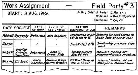
Figure 14-3.-A surveying work assignment sheet.
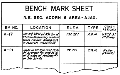
Figure 14-4.-A bench mark sheet. reduces the data to corresponding horizontal distances and elevations. This data serves as the basis from which the topographer does the plotting. The rodman must be trained to recognize and properly occupy the necessary control points. |
 
|
|
|
||
|
|
Integrated Publishing, Inc. - A (SDVOSB) Service Disabled Veteran Owned Small Business
|