Custom Search
|
|
 
|
||
|
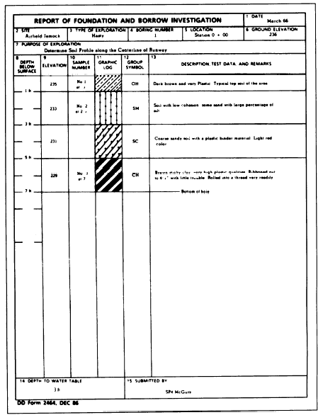
Field Sheets and Site Plans The survey engineer must furnish the soils analyst with suitable maps, overlays, and sketches for the plotting of pedological data. After the preparation of a reconnaissance field sheet of an area of several square miles, the soils analyst may require a sketch of a particular site in which many samples are taken for a more detailed study. In the absence of detailed instructions, the surveyor prepares a sketch on a scale of 1 inch = 400 feet and provides ranges and reference points to aid in plotting or tieing in specific positions of auger holes, drill holes, and lines of exposed rock or other pedological features. For plotting the data of a range, cross section, or series of boreholes, the soils analyst may require the surveyor to provide a basic plot on a scale of 1 inch = 100 feet or of 1 inch = 200 feet. Survey measurements will be conducted accordingly.SOIL SURVEYS The survey of soil conditions at the site of proposed military construction provides information about the nature, extent, and condition of soil layers; the position of the water table; drainage characteristics; and sources of possible construction materials. The survey of soil conditions is vital to both the planning and execution of military construction operations.OBJECTIVES OF A SOIL SURVEY The overall objective of a soil survey is to gather (explore) as much information of engineering significance as possible pertaining to the subsurface conditions in a specified area. Soil samples are collected for laboratory tests to determine if the existing soil conditions could support the type of structure planned for construction without adding other material for stabilization. The exploration is conducted in a specific manner to determine the following information: 1. Location, nature, and classification of soil layers 2. Condition of soils in place (density and moisture content)3. Drainage characteristics 4. Groundwater and bedrock 5. Development of a soil profile. Location, Nature and Classification of Soil LayersAdequate and economic earthwork and foundation design of a structure can be done only when the types and depths of soil are known. By the classification of the soils (discussed later in this chapter), you can predict the extent of problems concerning drainage, frost action, settlement, stability, and similar factors. While you can estimate the soil characteristics by field observations, for laboratory testing, you should obtain samples of the major soil types as well as less extensive deposits that may conversely influence design.Condition of Natural Soils The moisture content and density of a soil in its natural state plays an important part in design and construction. The moisture content of a soil in place may be so high as to require the selection of a different site. If the natural soil is sufficiently dense and meets the required specifications, no compaction of subgrade is required. On the other hand, extremely dense soil lying in cut sections maybe difficult to excavate with ordinary tractor-scraper units. Such dense soil often needs to be scarified or rooted before excavation.Drainage Characteristics Drainage characteristics, both surface and sub-surface, of a soil greatly affect the strength of the soil. This characteristic is controlled by a combination of factors. Some of these factors are void ratio, soil structure and stratification, temperature of soil, depth to water table, and the extent of local disturbance by roots and worms. Coarse-grained soils have better internal drainage than fine-grained soils.Groundwater and Bedrock All structures must be constructed at an elevation that ensures they will not be adversely affected by the groundwater table. If a proposed grade line lies below the elevation of the water table, either the grade line must be raised or the water table must be lowered by artificial drainage.The unexpected discovery of bedrock within the limits of an excavation greatly increases the time and equipment required to excavate. If the amount of rock is extensive, a change in grade or even a change of site may be the only way out. Field Notes and Soil Profile The engineer or EA in charge of the soil survey must keep accurate field notes and logs. This person is responsible for surveying, numbering, and recording each boring, test pit, or other exploration investigation. A log is kept of each test hole. It should show the depth below the surface (or the top and bottom elevations) of each soil layer, the field identification of each soil present at the site, and the number and type of each sample taken. Other items of information you need to include in the log are the density of each soil, changes in moisture content, depth to groundwater, and depth to rock. Keep a detailed field log of each auger boring or test pit made during the soil survey. A typical boring log is shown in figure 16-1.When you complete the survey, consolidate the information contained in the separate logs. Classify and show the depth of soil layers in each log. It is also helpful for the log keeper to show the natural water contents of fine-grained soils, when possible. Record this along the side of each log. Note the elevation of the groundwater table. This elevation is simply that of any free water standing in the test hole. To permit the water to reach maximum elevation, the engineer or EA should allow 24 hours to elapse before measuring it. This gives a more accurate measurement.
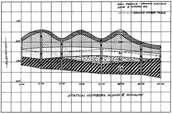
Figure 16-1.Typical boring log. The soil profile (fig. 16-2) is a graphical representation of a vertical cross section from the surface downward through the soil layers. It shows the location of test holes and of any ledge rock encountered, a profile of the natural ground to scale, field identification of each soil type, thickness of each soil stratum, profile of the water table, and profile of the finished grade line. Standard soil symbols should be used to indicate the various soil layers. The standard procedure is to add the proper color symbols representing the various soil types you discover. The soil profile has many practical uses in the location, design, and construction of roads, airfields, dams, and buildings. It greatly influences the location of the finished grade line; these should, of course, be located so as to take full advantage of the best soils available at the site. The profile also shows whether soils to be excavated in the course of construction are suitable for use in embankments or whether you require borrow soils instead. It may show the existence of undesirable soils, such as peat or other highly organic soils; it may also show the existence of bedrock too close to the surface. It aids in planning drainage facilities since these
Figure 16-2.Typical soil profile. are planned to take advantage of well-draining soils. Considerations relating to frost action become more important when frost-susceptible soils are shown on the profile. |
 
|
|
|
||