Custom Search
|
|
 
|
||
|
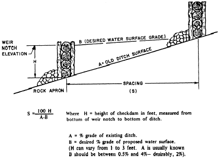
Final Cross Section When the final vertical and horizontal alignments of the road are fairly well fixed, final design is commenced. During this phase, final construction drawings are prepared and construction may begin. Before actual construction starts, final cross sections are prepared. From these final cross sections, slope stakes are set as described in the EA3 TRAMAN. Final cross sections are taken at each station along the center line of the road. They show the actual shape of the road, the horizontal width of components and their distances from the center line, the finish elevations, and the extremities of the cut and fill. They also show the slopes of the roadbed surface, ditches, and shoulders. The term final cross section is also applied to the as-built sections that are taken after the road is completed.The procedures used to plot cross sections are discussed in chapter 14 of the EA3 TRAMAN. You should review that chapter if you are unsure of the procedures.DRAINAGE Drainage is a major problem in the location, construction, and design of roads. A route should never be located where the drainage presents a problem that cannot be handled or would be too costly to handle. A route may have to be relocated because there is not enough material available to build a particular type of road. It may also have to be relocated because of a swamp or underground spring, high flood waters that can cover the road, or flash floods that can completely wash out the road. These are some of the reasons for planning alternate routes. During construction, the problem of drainage is mainly one of preventing standing puddles on the roadway. This problem is solved by slanting the worked surface of the road so that water can run off quickly or by cutting ditches, called bleeders, so that the water maybe carried away as it accumulates. Subsurface drainage problems are solved by raising the grade line of the road or lowering the water table. In either case, the distance between the water table and the top of the subgrade should be as great as possible. There are several ways of lowering the water table. In one way, deep, open ditches are set back beyond the roadway limits. These ditches intercept the water table, allowing groundwater to seep through the sides. The water then flows along the bottom and out the end of each ditch In another way of lowering the water table, a deep trench is dug exactly where the finished roadway ditch would be. The trench is then backfilled to a designated depth with rocks or large gravel of varying size, with the larger size at the bottom. The rocks are capped with a layer of branches or straw and the remainder of the trench backfilled with soil and compacted This trench is called a french drain (fig. 3-9). A tile drain, also shown in figure 3-9, is the same as a french drain except that a perforated pipe or tile is placed in the bottom of the trench. The trench is then backfilled with gravel to the desired depth. The minimum pipe grade is 0.3 percent with the maximum varying to meet conditions.Surface drainage involves water from direct precipitation, surface runoff, rivers, and streams. (Surface runoff is rainfall that is not absorbed by the soil but runs off a surface in sheets or rivulets.) Rainfall has an immediate effect upon a roadway. Obviously, rainwater would be a safety hazard or cause weak spots on the roadway if it were allowed to stand. Water that
Figure 3-10.-Check dams. falls upon the surface, or traveled way, is drained by crowning the surface; that is, constructing the traveled way so that the middle is higher than the edges. The traveled way in curves is drained by superelevating the surface; that is, constructing the traveled way so that the inside edge of the curve is lower than the outside edge.The water that drains from the surface continues over the shoulders. The shoulders always have a slope greater than, or at least equal to, the surface slope. This slightly increases the speed of the draining water and therefore increases the rate of drainage. The water then flows from the shoulder down the side of the fall, if in a fill section of a roadway. If the section is in a cut, the water flows into a roadway ditch. Roadway ditches are not normally in a fill section. |
||
|
||