Custom Search
|
|
 
|
||
|
CHAPTER 4 PROJECT DRAWINGS As you learned in chapter 10 of the EA3 TRAMAN, a construction drawing maybe one of several different types depending upon its intended use; and, in practice more than one type may be used during the design and construction of a new facility or structure. For instance, a presentation drawing (often based on a NAVFAC definitive design) maybe prepared to "sell" an idea or concept for anew facility. Them, after the design phase is completed, the facility is constructed using one or more sets of shop drawings and, of course, a set of project (or working) drawings. Shop drawings, as you recall, are those drawings, diagrams, or other-related data that are used to illustrate a material, product, or system; for example, a shop drawing might be an assembly drawing, prepared by a manufacturer, to describe the proper steps in assembling a set of commercially purchased cabinets. Project drawings are those drawings that describe to construction crews the construction of a complete facility or structure. These drawings are most often supplemented with shop drawings and project specifications (discussed in chapter 5 of this TRAMAN).Our discussions in this chapter center on project drawings as they pertain mostly to building construction. In the EA3 TRAMAN, you learned that NAVFAC project drawings are divided into the following categories or divisions: civil, architectural, structural, mechanical, electrical, and fire protection. Our discussions will include a brief review of the information you learned in the EA3 TRAMAN concerning these divisions. We also will expand on the EA3 TRAMAN information by including a discussion of heating, ventilating, and air-conditioning systems and drawings; riser diagrams for plumbing; and electrical wiring diagrams and schedules. In addition, you will be provided with information and tips that you can use when checking and editing project drawings. For NAVFAC policy regarding project drawing sizes, formats, and conventions, you should refer to Policy and Procedures for Project Drawing and Specification Preparation, MIL-HDBK-1006/1 and to the various Department of Defense (DOD) standards, military standards, and American National Standards Institute (ANSI) standards referred to in MIL-HDBK-1006/1.PROJECT DRAWING DIVISIONS The following paragraphs briefly describe the contents of the drawing categories or divisions mentioned above. CIVIL DIVISION The drawings contained in the civil division are those that describe the existing conditions and planned development of a project site. As applicable to any particular project, the division typically includes drawings that describe, at a minimum, the following information:1. Project location (shown on regional and vicinity maps) 2. Soil boring logs and profiles. 3. Existing site conditions to include terrain contours, buildings or structures, utilities, drainage, and other physical features on or near the project site. For small projects, this information can be shown in the site (plot) plan; however, for large or complex construction projects, it is often shown in a separate existing conditions plan.4. Planned demolition of existing buildings, structures, utilities, or other physical features that must be demolished as a part of the project. Dependent upon the complexity of the project, you may show this in the site plan or in a separate demolition plan.5. Planned grading for surface drainage (shown by contours or a combination of contours and spot elevations) and the planned grading and paving of driveways, access roads, and parking areas. For grading and paving, you should show plans, profiles, cross sections, and paving details as necessary to describe the new construction fully. Also show details for any curbs, gutters, sidewalks, and so forth. Again, dependent upon the complexity of the project, you may show all of this in the site plan or in a separate grading and paving plan.6. Proposed site plan showing property boundaries, construction limits, and exactly defined locations and finished floor elevations of new buildings or structures. Each building or structure should be located using a minimum of two location dimensions.
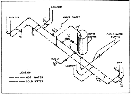
Figure 4-1.Hot- and cold-water riser diagram. Show the location and direction of all new utilities, unless separate utility site plans are included in other divisions, such as the mechanical, plumbing, or electrical divisions. That is sometimes done for large, complex projects |
 
|
|
|
||