|
||
|
|
||
| |||||||||||||||
|
|
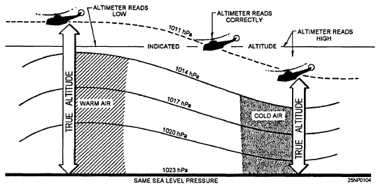
Click here to Order your Radar Equipment Online Altimeter Errors (Temperature) Another type of altimeter error is due to nonstandard temperatures. Even though the altimeter is properly set for surface conditions, it will often be incorrect at higher levels. If the air is warmer than the standard for the flight altitude, the aircraft will be higher than the altimeter indicates; if the air is colder than standard for flight altitude, the aircraft will be lower than the altimeter indicates. Figure 10-2 shows an example of altimeter errors due to nonstandard air temperatures.
Figure 10-2.-Altimeter errors due to nonstandard air temperatures. For more information, refer to The Airmans Information Manual, which is the official guide to flight information and air traffic control (ATC) procedures, and is used primarily by pilots, naval flight officers, and air traffic controllers. This publication is promulgated quarterly by the Federal Aviation Administration and contains useful information from a pilots perspective. All forecasters should be familiar with this publication.FORECASTING PROCEDURES The first step in the forecasting of altimeter settings is to forecast the sea level pressure for the valid time of the desired altimeter reading. This may be done by using the recommended procedures of prognosis presented in earlier chapters of this training manual.The next step is modification of the sea level pressure. After the value for the expected sea level pressure has been obtained, it is modified to reflect the diurnal pressure change at the location in question, Pressure tendency charts, locally prepared diurnal curves, and other available information may be used to obtain representative diurnal changes.The final result of the first two steps will normally be expressed in hectopascals since it is conventional to work in these units on related charts. If this is the case, then the resultant pressure in hectopascals must be converted into inches of mercury before it can be used for an altimeter setting. In the next section, we will consider the use of electro-optical (EO) systems by the Department of Defense. Because EO systems are being used more and more, it becomes important that Aerographers know about the problems associated with these systems. This information is now available on CD in Adobe PDF Printable Format |
|
Privacy Statement - Press Release - Copyright Information. - Contact Us - Support Integrated Publishing |