|
||
|
|
||
|
Page Title:
Initial Movement of Intense Cyclones |
||
| |||||||||||||||
|
|
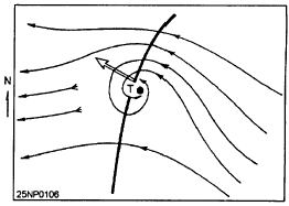
Click here to Order your Radar Equipment Online Initial Movement of Intense Cyclones The movement of cyclones that are undergoing or have just completed initial intensification (about 24 hours) will be as follows:. Storms developing in westward moving wave troughs in the easterlies move toward the west and also with a pole ward component given by an angle of approximately 20 to the right of the axis of the trough looking downstream. (See fig. 11-1.) . The motion of storms developing from preexisting vortices can be extrapolated from the track of these vortices.
Figure 11-1.-Illustration of initial movement of tropical cyclones forming in a wave trough In the easterlies.. Storms developing on the eastern edge of polar troughs initially move up the trough.. Pacific storms forming on equatorial shearlines usually are most active in the southern and southwestern portions at the start and they move slowly northeast. After 1 to 2 days, the influence of the trades becomes dominant and the storms turn back toward a direction ranging from west to north. (This appears to be true mainly for cyclones deepening near or west of 130E.). If a storm is discovered without information as to its past movement and the upper air current, it is best to start it along the climatological mean track and then secure the data necessary to determine the steering current. Extrapolation At present, the most practical prognostic technique used by the tropical meteorologist consists of extrapolating the past movement of the synoptic features on his or her chart into the future. The past track of a cyclone represents the integrated effects of the steering forces acting upon it. Accelerations and changes in course are the results of the changes in these steering forces. The effect of these forces can be examined and extrapolated directly from the past position of the cyclone.Before applying the extrapolation technique, the forecaster must attempt to smooth out the minor irregularities in the past track. The first step in the use of extrapolation is to determine the mean direction and speed of the cyclonic center between each two known positions. The next step is to determine the rate of change indirection and speed between successive pairs of fixes. The forecast position thus determined from extrapolation of movement should be smoothed out for minor irregularities and compared to the applicable climatological tracks of cyclones in the area. If large differences exist, the forecast should be completely reexamined. The climatological tracks should receive less weight for short-term forecasts of 6 to 12 hours and more weight for forecasts in excess of 24 hours.For short-term forecasts (6 to 12 hours), extrapolation is as reliable as any known method for movement.Steering The movement of a tropical cyclone is determined to a large extent by the direction and speed of the basic current in which it is embedded. This concept appears to work well as long as the cyclone remains small and remains in a deep broad current. By the time a tropical cyclone has reached hurricane intensity, these conditions seldom exist. It then becomes necessary to integrate the winds at all levels through which the cyclone extends and in all quadrants of the storm to determine the effective steering current. Although the principle is not fully understand and has not yet received universal acceptance as a valid rule, it does have practical applications. For example, changes in winds atone or more levels in the area surrounding the cyclone can sometimes be anticipated, and in such cases, a qualitative estimate of the resulting change in the movement of the cyclone can be made. Conversely, when it appears likely that none of the winds in the vicinity of the cyclone will change appreciably during the forecast period, no change in the direction and speed of movement should be anticipated. Further, this rule applies to situations of nonrecurvature and only some cases of recurvature. It is difficult to determine the steering current, since the observed winds represent the combined effects of the basic current and disturbances. As most storms extend into the high troposphere, it is better to calculate a "steering layer" than a steering level, since presumably the wind throughout most of the troposphere influences the storm movement. One writer recommends an integration of the mean flow between the surface and 300 hPa, over a band 8 in latitude centered over the storm. Another writer indicates that for moderate and intense storms the best hurricane steering winds would be found in the layer between 500 and 200 hPa and averaged over a ring extending from 2 to 6 latitude from the storm center.STREAMLINE ANALYSIS AND VECTOR AVERAGES. Other practical applications of the steering concept to short-range tropical cyclone motion use differing approaches in attempting to measure the basic current. One is by streamline analysis of successive levels to find a height at which the vertical circulation diminishes to a point such that the winds are supposedly representative of the undisturbed flow. Another method is to take vector averages of reconnaissance winds near the zone of strongest winds in the storm.USE OF OBSERVED WINDS ALOFT. When sufficient data are available, it has been found that the use of streamline analysis of successive levels usually gives valuable indications of tropical storm movement for as much as 24 hours in advance. However, since wind observations are usually scarce in the vicinity of a hurricane, their analysis is necessarily rather subjective. Some forecasters claim dependable results in using this concept when data were available to high levels near the storm. The technique is not based on the assumption that wind at any single level is responsible for steering the storm, since the forces controlling movement are active through a deep layer of the atmosphere.However, as successive levels are analyzed, a level is found at which the closed cyclonic circulation of the storm virtually disappears. This steering level coincides with the top of the warm vortex and varies in height with different stages and intensities of the storm. It maybe located as low as 20,000 feet or, in the case of a large mature storm, as high as 50,000 feet. It has been found in analysis that most weight should be given to the winds in advance of the storm within a radius of 200 to 300 miles in preference to those in the rear quadrants. The hurricane generally moves with a speed of 60 to 80 percent of the current at the steering level.This information is now available on CD in Adobe PDF Printable Format |
|
Privacy Statement - Press Release - Copyright Information. - Contact Us - Support Integrated Publishing |