|
||
|
|
||
| |||||||||||||||
|
|
Click here to Order your Radar Equipment Online FORWARD-LOOKING INFRARED (FLIR) LEARNING OBJECTIVES: Identify applications, limitations, and assumptions of the FLIR program. Interpret FLIR tables for detection ranges for predefined altitudes and target types. The FLIR System Prediction program determines the detection, categorization, and identification ranges of airborne FLIR sensors against surface targets. Ranges are given as a function of aircraft altitude and are for a 50 percent probability of detection, categorization, and identification of the target. The atmospheric data consisting of height, atmospheric pressure, air temperature, and dewpoint temperature come from the atmospheric environmental file (AEF). Surface wind speed and visibility are input from the keyboard when the program is run.
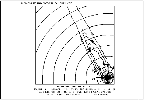
Figure 7-8.-Example output of the RADFO model.
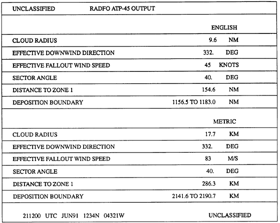
Figure 7-9.-Example ATP-45 output. Ranges may be predicted for several FLIR devices against surface or ASW targets. APPLICATION Users of the FLIR output include mission planners, pilots in the air wing, and the carrier group staff. The FLIR output can assist them in placing aircraft at altitudes to maximize FLIR detection of surface or ASW targets. LIMITATIONS AND ASSUMPTIONS The restrictions as well as the principles taken for granted in using the FLIR program areas follows: . The input environmental data are representative of the entire area of interest. Therefore, changes in the environment over time and over space are not accounted for. . Radiation is absorbed by molecules and both absorbed and scattered by aerosols. Other effects such as attenuation by rain, fog, and haze are neglected. . Targets are limited to rectangular bodies of fixed dimension with fixed target-to-background temperature differences, Teff. The target dimensions and temperatures correspond to "effective" target parameters. For example, a "periscope detection" attempts to emulate detection of a target area larger than a periscope, corresponding more to detection of a
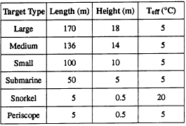
Table 7-4.-Effective Target Values submarine-generated wake. Table 7-4 lists effective target values used by the FLIR program. The effective dimensions produce more realistic ranges than use of actual target dimensions. . An airborne FLIR sensor is viewing targets well inside the horizon against an essentially blackbody sea. That is, the FLIR program does not account for changes in viewing angle resulting in a new target background and thus a new Teff. . If the relative humidity calculated from the input dewpoint depression is <35 percent, then a minimum value of 35 percent relative humidity is used only to calculate the aerosol extinction. Design of the model prevents accurate aerosol extinction calculations below 35 percent relative humidity. . All environmental data from the AEF must be quality controlled. Bad atmospheric data will produce unreliable results. If -1 is entered for an unknown surface visibility, the aerosol extinction coefficient is calculated with a visibility computed from the atmospheric sounding. The calculated visibility is displayed on output; however, it may or may not be similar to visibility conditions observed. The computed visibility is a limited approximation of the true visibility. If -1 is entered for unknown surface wind speed, the global average wind speed of 6.9 meters per second (about 14 knots) is used for calculations. Actual wind speeds lower than the global average generally yield longer ranges. Actual wind speeds higher than the global average will generally yield shorter ranges. The FLIR program does not calculate ranges at altitudes greater than the maximum height of the sounding, This limits the height of the FLIR sensor to the top of the meteorological data. FUNCTIONAL DESCRIPTION Fifty percent FLIR detection ranges are output for predefine altitudes and target types in tabular form based on the FLIR device selected. The 50 percent detection range curve is also depicted graphically for each of the target types. Output from this program is classified and should be labeled as required This information is now available on CD in Adobe PDF Printable Format |
|
Privacy Statement - Press Release - Copyright Information. - Contact Us - Support Integrated Publishing |
|
|
Integrated Publishing, Inc. - A (SDVOSB) Service Disabled Veteran Owned Small Business
|