|
||
|
|
||
| |||||||||||||||
|
|
Click here to Order your Radar Equipment Online NAVAL SEARCH AND RESCUE (NAVSAR) LEARNING OBJECTIVES Identify applications, limitations, and assumptions of the NAVSAR product. Interpret the three NAVSAR outputs. The NAVSAR program provides search assistance with two main functions: 1. Search Object Probability of Location Map 2. Recommended Search Plan Both functions use environmental data to compute the search objects drift from distress time to determine the area of the search where the object maybe found. Function (1) divides the area into several cell areas of equal size, and ranks them according to probability y of search object containment. The second function provides a search plan by determining either the search asset on-station durations or the probability of search success or search effort for cell areas. NAVSAR auxiliary functions include organizing and storing environmental and search object scenario data on a status board, and computing immersion survival time. APPLICATION NAVSAR provides information and planning assistance to the search mission coordinator (SMC) during search and rescue incidents at sea. NAVSAR is designed to assist the SMC in deciding where to search for a target, how many assets to commit to a search, and how to assign those assets to maximize their effectiveness.
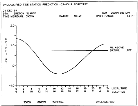
Table 8-1.-Example Output of a 24-hour Tide Time/Height Graph
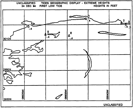
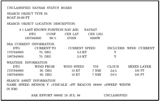
Figure 8-1.-Example output of the Tides Geographic Display. NAVSAR uses the search objects description its last known location, and environmental data to estimate the search object location at the time of the search. Using search asset information provided by the SMC, the program will provide search recommendations in terms of rectangular areas in which to search. LIMITATIONS AND ASSUMPTIONS The restrictions as well as the principles taken for granted in using the NAVSAR program areas follows: . There are three search object location scenarios to define the search objects location prior to distress time. These are Last Known Position, Trackline, and Area of Uncertainty. The operator can select up to five plans of action to enter on the status board, but only one can be a Trackline scenario. . There are two processing modes used by NAVSAR that result in different output formats for the recommended search plan. The first processing mode is referred to as level I. The level I mode occurs when the only object location scenario is the Last Known Position scenario. The recommended search is evenly distributed over the entire area, All other location scenarios and combinations of scenarios invoke the level II mode. The recommended search plan will contain a search effort density map. Search effort concentration is given as swept areas. . A level I recommended search plan can be added to the status board. A level II recommended search plan cannot be added to the status board, but can be entered manually as a search plan via the search plan data. . The operator selects the type of object to be searched from a predefine list. . A search object trackline is described by up to four leg segments defined as either all great-circle or rhumb lines. . Each search object location scenario must have a confidence value entered by the user. The total confidence values for all scenarios must add up to 100 percent. When revising the status board, the operator enters anew search object location scenario, and at least one of the previous location scenario confidence entries must be changed so that the total confidence for all scenarios is once again 100 percent. . Up to eight weather and sea-current observations can be entered into NAVSAR. Sea-current observations that do not include the wind current need wind-speed and -direction observations prior to the time of the sea-current observation. Ideally, wind-speed and-direction observations representing conditions 48 hours before the sea-current observation should be entered. If there are no sea- or wind-current observations, sources of sea-current data consists of Fleet Numerical Meteorological and Oceanographic Center (FNMOC) monthly current charts and the Naval Oceanographic Office (NAVOCEANO) surface-current atlases. . A maximum of five search assets can be entered on the status board for a particular search. . Up to five search object probability maps can be requested for display in sequence. . A maximum of five search plans can be added to the status board. . NAVSAR computes the sweep widths for both visual and electronic search sensor types. For any other sensor types, the user must provide the sweep width. . The searching altitude to enter for aircraft is the flight altitude; for ships, it is the bridge height or the height of the sensor. . Search object location maps can only be produced after the earliest distress scenario date-time group (DTG). FUNCTIONAL DESCRIPTION NAVSAR can be subdivided into three main functions: 1. The status board maintenance function performs the data base management. 2. The map generation function purpose is to produce probability maps for the search object at user-entered times based on the data available in the current status board. 3. The search planning function is to provide search plan recommendations that allow the most effective use of the available search assets. Table 8-2 shows an example output of the View Status Board. This is an organized table of the search object description, location scenarios ejection
Table 8-2.-Example Output of the NAVSAR View Status Board information, sea-current data, weather observations, search asset data, and search plan information. Figure 8-2 shows an example output of the search location density map. The output shows numbered cells that represent relative probabilities of the search object being located within the cell. Table 8-3 shows an example output of a search recommendation, level I. This is a tabular display describing a recommended rectangular search area. The available assets are listed with their on-station duration and area of coverage. Also shown is the position of the search and the cumulative detection probability of previous searches. This information is now available on CD in Adobe PDF Printable Format |
|
Privacy Statement - Press Release - Copyright Information. - Contact Us - Support Integrated Publishing |
|
|
Integrated Publishing, Inc. - A (SDVOSB) Service Disabled Veteran Owned Small Business
|