|
| |
[ Back ] [ Home ] [ Up ] [ Next ]
Click
here to Order your Radar Equipment Online
Occluded Fronts
Mountain ranges have much the same effect on
occluded fronts as they do on warm and cold fronts.
Cold type of occlusions behave as cold fronts,
and warm type of occlusions behave as warm
fronts. The occlusion process is accelerated when
a frontal wave approaches a mountain range.
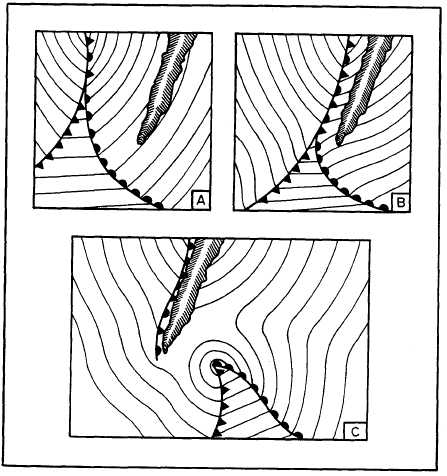
The warm front is retarded; but the cold front
continues at its normal movement, quickly overtaking
the warm front (views A and B of fig. 4-7-3).
When a cold front associated with an occluded frontal
system passes a mountain range, the cold front
may develop a bulge or wave. In the case of
an occlusion, anew and separate low may form at
the peak of the warm sector as the occluded front
is retarded by a mountain range (view C of fig.
4-7-3). The low develops on the peak of the wave
because of induced low pressure that results when
air descends on the leeward side of the mountain
and warms adiabatically.
The development of a new low on a frontal wave
and ultimate separation from its original cyclone
is a fairly common occurrence. This can
occur over open oceans but occurs more

Figure
4-7-3.Acceleration of the occlusion process and development of a frontal wave
cyclone.
frequently
along the west coast of mountainous continents
and along the west coast of Japan. The
typical stages of this type of frontal modification
are shown in figure 4-7-4. Orographic
features play a great role in certain preferred
areas of this phenomena, but over the ocean
some other factors must be operative. In some
cases, a rapidly moving wave overtakes the slow
moving occlusion and may be the triggering mechanism
for this cyclogenesis. Whatever the
exact nature of its causes, this type
of cyclogenesis proceeds with great rapidity. Initially,
the old occlusion in view A of figure 4-7-4
either moves against a mountain range or is
overtaken by another cyclone. The occlusion then
undergoes frontolysis (view B of fig. 4-7-4). The
new occlusion forms immediately and soon overshadows
its predecessor in both area and intensity
(view C of fig. 4-7-4). However, the cold occlusion,
having greater vertical extension, exerts
a certain control on the movement of the new
center, which at first follows the periphery of
the old center. Later, the two centers pivot cyclonically
(view D of fig. 4-7-4) about a point somewhere
on the axis joining them until the old center
has filled and loses its separate identity. This
can take place with either a warm or cold occlusion.
If it occurs near a west coast in winter, there
is a good chance the new occlusion is warm. This
formation of a secondary wave cyclone, the
dissipation of the original occluded front, and the
rapid development of a new occlusion is sometimes
called skagerraking, pressure jump, or bent-back
occlusion:


Figure
4-7-4.Stages in the development of a secondary wave cyclone.
[ Back ] [ Home ] [ Up ] [ Next ]
|
