|
||
|
|
||
| |||||||||||||||
|
|
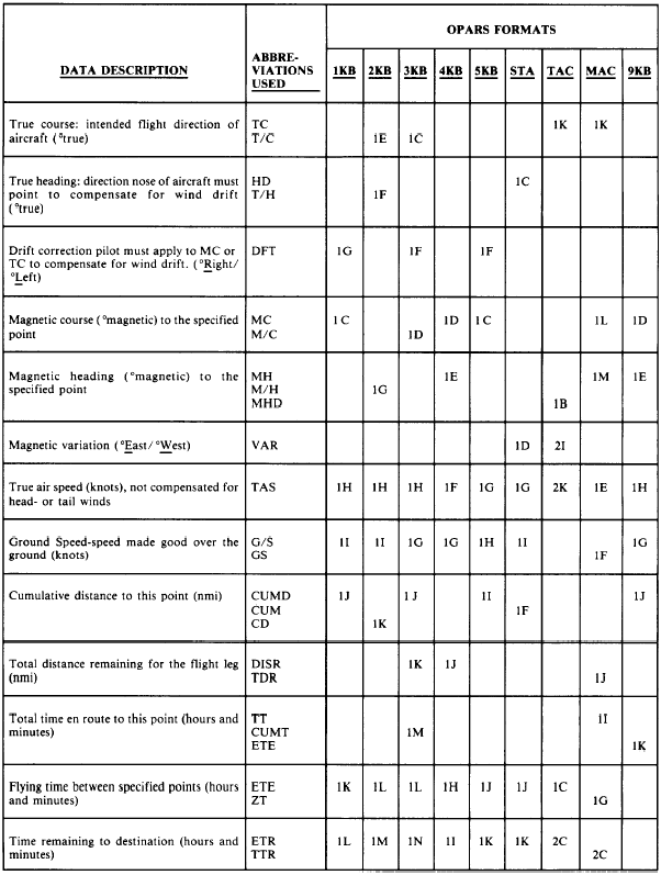
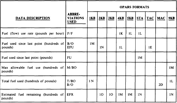
EN ROUTE DATA The last type of data that the OPARS CFPs contain is en route data. In the majority of the formats, en route data consists of (1) a section of point locations and associated information at these points in the flight, which we will call en abbreviations with an explanation, flight profile and (4) a total windfactor for the flight. En route Point Details Look again at figure 4-6-1, at the section identified as en route data. The en route point details begin with one or two lines of en route point locations, with associated navigation information, flight times and distances, and fuel usage information. The data contained in the columns in each line is identified with an abbrevia-tion at the top of each column. The one or two lines of data are repeated for each point used in the routing. This section of the en route data which provides specified points and associated information is used in all of the CFP formats except the Abbreviated format, which does not contain any specific point data, and the How-goes-it format, which provides a graph of the en route location identifiers plotted on a scale of Fuel remaining in the aircrafts tanks (in pounds) versus nautical miles traveled. The specific information that is included in each formats en route point details section differs slightly, and is identified in table 4-6-3. Generally, this section of the en route data identifies specific points along the intended flight route, and provides specific air-craft performance information at those points.In the Standard format this information is contained in the section called the Navigational Log.The en route point details section of the Tactical format is very similar to the Kneeboard, Standard, and Military Airlift Command formats except blanks are left in the lines of data for pilot/navigator-entered comments, such as under the headings ATA (for actual time of arrival at the location), AFU (for actual fuel use to the point), and AFR (for actual fuel remaining).Latitude/Longitude Listing The CFP formats that do not provide latitude and longitude with each navigation point within the data lines of the en route point details section will provide a listing of the specific en route point identifiers and the associated latitude/longitude. Table 4-6-3.-Data Presented in the En Route Point Details Section of the Various OPARS Formats
Table 4-6-3.-Data Presented in the En Route Point Details Section of the Various OPARS FormatsContinued
Table 4-6-3.-Data Presented in the En Route Point Details Section of the Various OPARS FormatsContinued
This listing usually immediately follows the en route point details section. Latitudes are preceded with either a N, for north latitude, or an S, for south latitude, while longitudes are preceded by an E, for east longitude, or a W, for west longitude. All latitudes and longitudes either in the Latitude/Longitude listing or in the en route point details listing are given in degrees, minutes, and tenths of minutes. For example, a longitude listed as W179528 would mean 179 degrees, 52.8 minutes west longitude. |
|
Privacy Statement - Press Release - Copyright Information. - Contact Us - Support Integrated Publishing |