|
||
|
|
||
|
Page Title:
Consideration of Geography and Climatology |
||
| |||||||||||||||
|
|
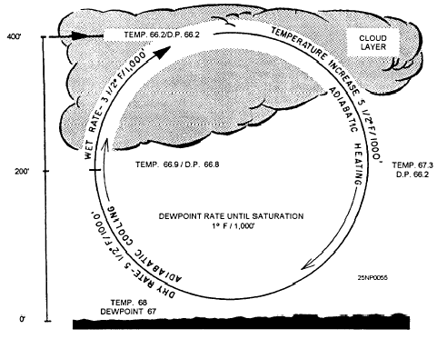
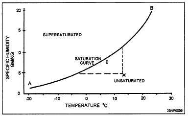
Click here to Order your Radar Equipment Online Consideration of Geography and ClimatologyCertain areas are more favorable climatologically for fog formation during certain periods of the year than others. All available information pertaining to climatology should be compiled for your station or operating area to determine the times and periods most favorable for fog formation.You should also determine the location of the station with respect to air drainage or upslope conditions. Next, determine the type of fog to which your location would be exposed. For example, inland stations would be more likely to have radiation fog and shore coastal stations advection fog. A determination should then be made of air trajectories favorable for fog formation at your station.Frontal Fog Frontal fogs are associated with the forecasting of the movement of fronts and their attendant precipitation areas. For example, fogs can form in advance of a warm front, in the warm air section behind the warm front (when the warm air dewpoint is higher than the cold air temperature), or behind a slow moving cold front when the air becomes saturated.Air-mass Fog The first step in the forecasting of air-mass fogs is to determine the trajectory of the air mass and estimate the changes that are expected to occur during the night. If the air mass has been heated during the day and there was no fog the preceding morning, no marked cloud cover during the day, and no overwater trajectory, fog will not form during the night. However, during fall and winter, nights are long and days are short, and conditions are generally stable. When a fog situation has been in existence, the same conditions tend to remain night after night, and the heating during the day is insufficient to effectively raise the temperature above saturation. Also, determine if the air has had a path over extensive bodies of water, and whether this path was sufficient to raise the humidity or lower the temperature sufficiently to form fog. Then construct nomograms, tables, etc., by using dewpoint depression against time of fog formation for various seasons and winds; modify these in the light of each particular synoptic situation.FACTORS TO BE CONSIDERED IN FOG AND STRATUS FORMATIONWind, saturation of the air mass, nocturnal cooling, and air-mass trajectories have a role in the formation of fog or stratus clouds.Wind Wind velocity is an important consideration in the formation of fog and/or low ceiling clouds. When the temperature and dewpoint are near one another at the surface and eddy currents are 100 feet or more in vertical thickness, adiabatic cooling in the upward portion of the eddy could give the additional cooling needed to bring about saturation. Any additional cooling would place the air in a temporary supersaturated state. The extra moisture will then condense out of the air, producing a low ceiling cloud. Adiabatic heating in the downward portion of the eddy will usually evaporate the cloud particles. If all cloud particles evaporate before reaching the ground, the horizontal visibility should be good. However, if many particles reach the ground before evaporation, the horizontal visibility will be restricted by moderate fog. Clouds that form in eddy areas may at first be patchy and then become identified as ragged stratus. If the cloud forms into a solid layer, it will be a layer of stratus. When conditionally unstable air is present in the eddy, or if the frictional eddy currents are severe enough, stratocumulus clouds will form in the area. See figure. 5-13.Saturation of the Air Mass The saturation curve in figure 5-14 shows the amount of moisture in grams per kilogram the air will hold at various temperatures.The air along the curve is saturated and is at its dewpoint. Any further cooling will yield water as a result of condensation; hence, fog or low ceiling clouds (depending upon the wind velocity) will form.Nocturnal Cooling Nocturnal cooling begins after the temperature reaches its maximum during the day. Cooling will continue until sunrise, or shortly thereafter. This cooling affects only the lower limits of the atmosphere. If nocturnal cooling reduces the temperature to a value near the dewpoint, fog or low clouds will develop. The wind velocity and terrain roughness will control the depth of the cooled air. Calm winds will allow a patchy type of ground fog or a shallow, continuous ground fog to form. Winds of 5 to 10 knots will usually allow the fog to thicken vertically. Winds greater than 10 knots will usually cause low stratus or stratocumulus to form. See figures 5-15 and 5-16 for examples of fog and stratus formation.The amount of cooling at night is dependent on soil composition, vegetation, cloud cover, ceiling, and other factors. Cloud cover based below 10,000 feet has a greenhouse effect on surface temperatures, absorbing some terrestrial radiation and reradiating a portion of this heat energy back to be absorbed by the land. This causes a reduction in nocturnal cooling. Nocturnal cooling between 1530 local and sunrise will vary from as little as 5 to 10 (with an overcast sky condition based around 1,000 feet), to 25 or 30F with a clear sky or a cloud layer above 10,000 feet. Other factors and exceptions must also be considered. If a front is expected to pass the station during the night, or onshore winds are expected to occur during the night, the amount of cooling expected would have to be modified in light of these developments.
Figure 5-13.-How wind velocity can cause a low cloud layer.
Figure 5-14.-Saturation curve. An estimate of the formation time of fog, and possibly stratus, can be aided greatly if some type of saturation time chart, such as that illustrated in figure 5-17, can be constructed on which the forecasted temperature versus the forecasted dewpoint can be plotted. To use this diagram, note the maximum temperature and consider the general sky condition from the surface chart, forecasts, or sequence reports, By projecting the temperature and dewpoint temperature, an estimated time of fog formation can be forecast. If smoke is observed in the area, fog will normally form about 1 hour earlier than the formation line indicates on the charts because of the abundance of condensation nuclei. This information is now available on CD in Adobe PDF Printable Format |
|
Privacy Statement - Press Release - Copyright Information. - Contact Us - Support Integrated Publishing |