Custom Search
|
|
 
|
||
|
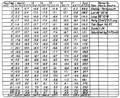
DATUM Tidal datums are specific tide levels that are used as surfaces of reference for depth measurements in the sea and as a base for determining elevations on land. In leveling operations, the tidal datum most commonly used is the MEAN SEA LEVEL. Other datums, such as mean low water, mean lower low water, mean high water, and mean higher high water, are sometimes used, depending upon the purpose of the survey. Still other datums have been used in foreign countries. When conducting leveling operations overseas, you should check into this matter carefully to avoid mistakes.Mean Sea Level Mean sea level (MSL) is defined as the average height of the sea for all stages of the tide after long periods of observations. It is obtained by averaging the hourly heights as they are tabulated on a form similar to that
Figure 14-2.-Ways of using spikes as bench marks.
Figure 14-3.Sample format showing hourly heights of tide required for computing average mean sea level (MSL). shown in figure 14-3. The heights on this form are added both horizontally and vertically. The total sum covering 7 days of record is entered in the lower right-hand corner of the page. The mean for each calendar month is found by combining all daily sums for the month and dividing by the total number of hours in the month. The monthly mean, to two decimal places, is entered on the sheet that includes the record for the last day of the month. Yearly means are determined from the monthly means, and a mean is taken of all yearly means for the period of record. Three or more years of record should be used for a good determination of sea level. The actual value varies somewhat from place to place, but this variation is small. The station used for MSL determinations should be on the open coast or on the shore of bays or harbors having free access to the sea. Stations on tidal rivers at some distance from the open sea will have a MEAN RIVER LEVEL that is higher than mean sea level because of the river slope. It should be noted that mean sea level is NOT identical with mean tide level (MTL). The latter is derived from the mean of all high and low points on the tidal curve. But MSL is derived from the mean of a much larger number of points taken at hourly intervals along the tidal curve.The datum universally used in leveling is mean sea level (MSL), and it is considered to be the zero unit. The vertical distance of a given point above or below this datum then becomes the elevation of that point. Other Datums Along the Atlantic coast of the United States, the mean low water (MLW) datum has been generally adopted as the datum used for hydrographic surveys. It is the mean of all low water tides observed over a long period (usually a 19-yr period). Mean lower low water (MLLW) has been generalIy adopted for hydrographic surveys along the Pacific coast of the United States, Hawaii, Alaska, and the Philippine Islands. It is the mean of the lower of the two low water tides for each day observed over a long period. Mean low water spring (MLWS) is used on the Pacific coast of the Panama Canal Zone. It is defined as the mean of the low waters of the spring tides occurring a day or two after a full moon and is obtained by subtracting one-half of the range of the spring tides from the mean sea tide level. |
 
|
|
|
||