Custom Search
|
|
 
|
||
|
LOCATIONS OF POINTS The end result desired in a triangulation survey is the horizontal locations of the points in the system, by bearing and distance. Methods of converting deflection angles to bearings and converting bearings to exterior or interior angles are described in the EA3 TRAMAN. The following paragraphs explain how to determine the bearings of lines of a quadrilateral. Bearing and Distance Figure 15-29 shows the quadrilateral we have been working on, with the computed values of the sides inscribed. Take station D as the starting point. Suppose that, by an appropriate method, you have determined the bearing of DA to be N150000E, as shown. To have a good picture of how you proceed to compute for the bearing of the next line, AB, you must superimpose the meridian line through the starting point, laying off approximately the known bearing; in this case, N150000E. Now draw your meridian through point A. From figure 15-29 you can see that the line AB bears southeast, and you can find its bearing by subtracting 150000 from angle A. Angle A is the sum of angles 1 and 2 (384408 + 234435), or 622843, as you should recall from figure 15-28. The bearing angle of AB, then, is 622843 150000, or 472843.Therefore, the complete bearing of line AB is S472843E.
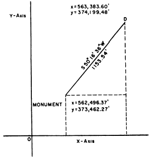
Figure 15-30.Coordinates. You would find the bearing of BC and CD similarly, except that you have to watch for the angle you are after. Always remember that a bearing angle does not exceed 90 and is always reckoned from north or south. To find the bearing of BC, you must find the sum of angle B (angles 3 and 4, fig. 15-28) plus the bearing angle of AB and then subtract it from 180; you can see that BC bears southwest, so just add this designation to the proper place in the bearing angle for BC. In this case, the bearing of BC will be 1800000 (421908 + 445159 + 472843), or S452010W. The bearing of CD is equal to angle C minus the bearing angle of BC.Coordinates Suppose that you are tying the quadrilateral shown in figure 15-29 into a state grid system. The nearest monument in this system lies 1,153.54 feet from station D, bearing S501636W from D, as shown in figure 15-30. This means that the bearing from the monument to D is N501636E. Suppose that the grid coordinates of the monument are y = 373,462.27 feet and x =562,496.37 feet.The latitude of the line from the monument to station D is 1,153.54 cos 501636, or 737.21 feet. The departure of the same line is 1,15354 sin 501636, or 887.23 feet. The y coordinate of station D equals the y D, or 373,462.27 + 737.21, or 374,199.48 feet. The x coordinate of station D equals the x coordinate of the monument plus the departure of the line from the monument to D, or 562,496.37 + 887.23, or 563,383.60 feet.Knowing the coordinates of station D, you can now A. The latitude of DA is 700.00 cos 150000, or 676.15 feet. The DA is 700.00 sin 150000, or 181.17 feet.The y coordinate of station A is equal to the y D plus the latitude of DA, or
Figure 15-31.Sun observation field notes. 374,199.48 + 676.15, or 674,875.63 feet. The x coordinate of station A is equal to the x coordinate of D plus the departure of DA, or 563,383.60 + 181.17, or 563,564.77 feet. The coordinates of the other stations can be similarly determined. |
 
|
|
|
||