|
||
|
|
||
| |||||||||||||||
|
|
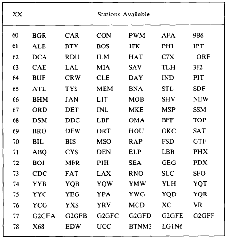
LFMII Forecast Output The LFM forecast output is available in bulletin format for many geographical regions. Most are identified by the MANOP FOUSxx available.Table 4-3-4.-LFM Forecast Data Regions and Stations Available With The MANOP FOUSxx KWBC, Where xx is the Region
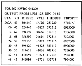
Number Table 4-3-5 shows an example of the first block of data from a typical LFM forecast data bulletin. Each bulletin usually has five or six data blocks, one for each station. The second data block would appear just to the right of this data block so that two columns of station data are formed.Lets break this example down to find what information is presented. The first line is the MANOP with the date-time group of the message. The second line identifies the message as LFM output from the 1200Z December 04, 1989 data base. The third line gives a data format, which we will discuss later. The fourth line lists the station identification for which the data is given in the first column (in this case DCA for Washington, D.C.), then continues with data analyzed at the data base time on the remainder of the line. The fifth through twelfth lines give the actual forecast data in 6-hour increments, and each begins with the number of hours from the analysis time that the forecast is valid. For instance, in the last line the first two digits are 48. This means this line of data is the 48-hour forecast from 1200Z 4 December, valid at 1200Z 6 December.As you can see, the data is arranged into columns. Each column has a header that identifies the data in that column. In the following explana-tion, we will use the seventh line of the bulletin, or the 18-hour forecast, as an example to further clarify each point. The column headers represent the following data:RH is the mean relative humidity in the lowest three layers of the LFM model (refer back Table 4-3-5.-A Data Block From an LFM Forecast Bulletin With a MANOP Header and an Identification Line
to figure 4-3-1) or the surface-to-490-millibar level (about 19,000 feet MSL). In our example, the mean surface-to- 19,000-foot relative humidity is 68 percent.R1 is the mean relative humidity in the boundary layer (the lowest LFM layer), which is from the surface to 50 millibars above the surface, or to about 1,400 feet AGL. In the example, this value is 75 percent. R2 is the mean relative humidity in layer 2 of the LFM, from 50 millibars above the surface to about 720 millibars, or from about 1,400 feet AGL to about 9,000 feet AGL. You should read this value as 65 percent in our example. R3 is the mean relative humidity in layer 3 of the LFM, from 720 millibars to 490 millibars, or about 9,000 feet AGL to 19,000 feet AGL. In our example, we should read the mean relative humidity as 99 percent. (This is the maximum humidity that the program calculates.) VV is the vertical velocity at 700 millibars, in microbars per second. In the 18-hour forecast, the value 016 means +16 microbars per second. minus sign. A 04 would mean 04 microbars per second, or that the air is sinking at 4 microbars per second. LI is the Lifted Index, in degrees Celsius. In our example 24 means 24C. Negative LI values are subtracted from 100. A 96, for instance, would mean a lifted index of 04C. HH is the 1000-to-500-millibar-layer thickness, in decimeters, with the hundreds value (usually a 5) omitted. In the example, the 37 means 537 decimeters, or 5,370 meters. DD is the mean wind direction at the top of the boundary layer, or the approximate 1,400-foot wind direction, in hundreds and tens of degrees. In the example, the wind direction is forecast as 250. FF is the mean wind speed at the top of the boundary layer, in whole knots. We should read 14 knots in our example. TB is the mean potential temperature through the boundary layer, in kelvin, with the hundreds units (usually a 2) omitted, In the example, our mean potential temperature through the boundary layer is 273 K. Converting this temperature into degrees Celsius by subtracting 273 will yield the approximate temperature at 25 millibars above the surface. PS is the forecast sea level pressure, in tens and units of millibars. The 03 in our example means 1,003 millibars. PTT is the 6-hour accumulated precipita-tion for the period ending at the valid time of the forecast, in hundredths of an inch. This is a liquid equivalent in the case of snow. In the example, the 003 means 3 hundredths of an inch of precipitation has accumulated in the 6-hour period ending at 0600Z (18 hours after the analysis time of 1200Z). Although the LFM data is expected to be available for a few more years, the NGM output, already available, was designed to replace the LFM output to obtain greater forecast accuracy. |
|
Privacy Statement - Press Release - Copyright Information. - Contact Us - Support Integrated Publishing |